파일:Babylone 1.PNG
둘러보기로 이동
검색으로 이동

미리 보기 크기: 800 × 559 픽셀 다른 해상도: 320 × 224 픽셀 | 640 × 447 픽셀 | 982 × 686 픽셀
원본 파일 (982 × 686 픽셀, 파일 크기: 960 KB, MIME 종류: image/png)
| 설명 |
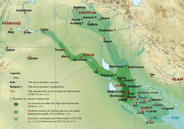
English: Map of the kingdom of the First Dynasty of Babylon from the beginning of the reign of Hammurabi (1792-1750 BC according to middle chronology) to the fall of Babylon in 1595 BC. The maximal extension of the kingdom under the reigns of Hammrabi and his son Samsu-iluna includes cities that have been taken by those kings, but probably dominated at best a few years, like Tuttul, Nineveh and Shekhna. The domination of Terqa by the successors of Samsu-iluna is probable because of some of them appear in the name years of tablets excavated there (Ammi-saduqa, Samsu-ditana). Français : Carte du royaume de la Première dynastie de Babylone depuis le début du règne de Hammurabi (1792-1750 av. J.-C. selon la chronologie moyenne) jusqu'à la chute de Babylone en 1595. L'extension maximale du royaume sous les règnes de Hammurabi et Samsu-iluna inclut des villes qui ont été dominées au mieux quelques années comme Tuttul, Ninive ou Shekhna. La domination de Terqa sous les successeurs de Samsu-iluna est probable du fait de l'utilisation du nom de certains d'entre eux pour dater des tablettes exhumées sur ce site (Ammi-saduqa, Samsu-ditana). |
| 날짜 | (UTC) |
| 출처 | |
| 저자 |
|
| 다른 버전 |
[]
|


| 이 그림은 수정된 그림으로, 원래 그림에서 디지털 변환이 이루어진 그림입니다. 수정 사항 : Extension du royaume, villes, légende.. 원래의 그림 : Near East topographic map-blank.svg:
|
나는 아래 작품의 저작권자로서, 이 저작물을 다음과 같은 라이선스로 배포합니다:
- 이용자는 다음의 권리를 갖습니다:
- 공유 및 이용 – 저작물의 복제, 배포, 전시, 공연 및 공중송신
- 재창작 – 저작물의 개작, 수정, 2차적저작물 창작
- 다음과 같은 조건을 따라야 합니다:
- 저작자표시 – 적절한 저작자 표시를 제공하고, 라이센스에 대한 링크를 제공하고, 변경사항이 있는지를 표시해야 합니다. 당신은 합리적인 방식으로 표시할 수 있지만, 어떤 방식으로든 사용권 허가자가 당신 또는 당신의 사용을 지지하는 방식으로 표시할 수 없습니다.
- 동일조건변경허락 – 만약 당신이 이 저작물을 리믹스 또는 변형하거나 이 저작물을 기반으로 제작하는 경우, 당신은 당신의 기여물을 원저작물과 동일하거나 호환 가능한 라이선스에 따라 배포하여야 합니다.

|
GNU 자유 문서 사용 허가서 1.2판 또는 자유 소프트웨어 재단에서 발행한 이후 판의 규정에 따라 본 문서를 복제하거나 개작 및 배포할 수 있습니다. 본 문서에는 변경 불가 부분이 없으며, 앞 표지 구절과 뒷 표지 구절도 없습니다. 본 사용 허가서의 전체 내용은 GNU 자유 문서 사용 허가서 부분에 포함되어 있습니다. |
이 라이선스 중에서 목적에 맞는 것을 선택하여 사용할 수 있습니다.
기존 올리기 기록
This image is a derivative work of the following images:
- File:Near_East_topographic_map-blank.svg licensed with Cc-by-sa-3.0,2.5,2.0,1.0, GFDL
- 2009-08-18T18:31:37Z Sémhur 2425x1581 (2442670 Bytes) 3 - New try
- 2009-08-17T15:39:22Z Sémhur 2425x1581 (1815374 Bytes) 2 - With the background...
- 2009-08-17T15:37:36Z Sémhur 2425x1581 (2836 Bytes) {{Information |Description={{en|1=Blank physical map of the [[:en:Near East|Near East]]}} {{fr|1=Carte physique vierge du [[:fr:Proche-Orient|Proche-Orient]].}} |Source={{own}} |Author=[[User:Sémhur|Sémhur]] |Date=2008-08-1
Uploaded with derivativeFX
파일 역사
날짜/시간 링크를 클릭하면 해당 시간의 파일을 볼 수 있습니다.
| 날짜/시간 | 크기 | 사용자 | 설명 | |
|---|---|---|---|---|
| 현재 | 2010년 9월 29일 (수) 16:16 | 982 × 686 (960 KB) | wikimediacommons>Zunkir | {{Information |Description={{en|1=Map of the kigdom of the First Dynasty of Babylon from the beginning of the reign of Hammurabi (1792-1750 BC according to middle chronology) to the fall of Babylon in 1595 BC. The maximal extension of the kigdom under the |
이 파일을 사용하는 문서
다음 문서 1개가 이 파일을 사용하고 있습니다: